GERMANY-2
(Last updated 12/25/07)
The Rhine River, backbone of the busiest
inland waterway network in Western Europe, arises in the Alps
in eastern Switzerland, flows along the Swiss border with Liechtenstein,
thru a sliver of land at the tip of Austria, then back into Switzerland's
Lake Constance to journey west. At Basle, it bends sharply north
to leave Switzerland and flow thru the valley between the French
Vosges range and Germany's Black Forest, then continues north
into Germany until it turns gradually west again just past Duisburg,
one of the largest inland ports in the world (at the confluence
of both the Ruhr River and the Hern-Rhine Canal), to flow thru
the Netherlands as it finishes its 820 mile journey to the North
Sea.
In the middle Rhine, the river turns
sharply west outside of Wiesbaden when it bumps into the southern
hillsides of Hessen's Taunus range (they form the south-facing
slopes of the Rheingau), then almost due north again at the town
of Bingen (located at the confluence of the Nahe River), plunging
past the rapids and rocks of the Bingerloch (whirlpool) into one
its wildest sections, a narrow 35-mile long gorge cut thru the
schist massif of the Rhenish Slate Mountains (called the Loreley
region after its most famous landmark). Because of the commercial
importance of river traffic on the Rhine since Roman times, and
especially in the Middle Ages, the cliffs and steep hills of this
small gorge hold the highest density of castles of any river valley
in the world - for he who could control and tax the flow of goods
on the Rhine had wealth and power indeed...
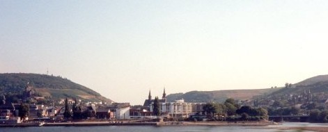
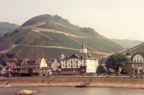
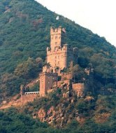
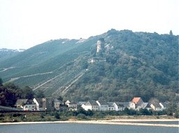
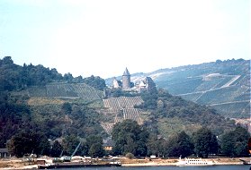
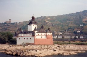
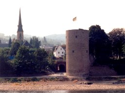
A view of the town of Bingen, with
its latest version of the Drusus Bridge (rebuilt after WWII; the
first was constructed by the Romans) over the mouth of the Nahe
on the right; the twin spires of the Basilica of St Martin (1416)
can be seen in the center of town (the original was built in 793,
rebuilt in 1220, destroyed by fire in 1403). Burg ("Castle")
Klopp (right) is just visible above town on the left - the "modern"
castle (built in 1282 on the site of the Roman Castellum Bingium,
destroyed many times thereafter - including by the French in 1689,
restored by a Cologne businessman in the mid-19th century) has
served as City Hall since 1897
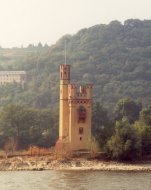
 The Mäuseturm (left; originally
"mautturm," or toll tower, now the Mouse Tower - from
a legend about the downfall of the 9th century Archbishop Hatto
II of Mainz), was built ca 1210 on an islet (first fortified by
the Romans) just downstream from Bingen; the ruins of Burg Ehrenfels
(center; built 1208-19 by the brothers von Bolanden, damaged by
Swedish troops in 1636 during the Thirty Years War, destroyed
by the French during the War of Palatine Succession in 1688) sits
directly across the river in the middle of a vine-covered bluff
- straddling the narrowest part of the river in tandem with the
Mäuseturm, it served as a toll station for the Archbishops
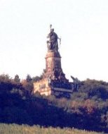
of Mainz. The 114-ft Niederwald Monument (right; 1877-83; designed
by Johann Schilling of Dresden, topped by the 33-ft bronze statue
of Germania, dedicated by Wilhelm I to commemorate the re-establishment
of the German Empire after the Franco-Prussian War of 1870-1)
stands above Ehrenfels near the summit of the Niederwald-Denkmal,
a broad hill that constitutes the southwestern apex of the Taunus
(Rüdesheim and Assmannshausen sit at the foot of its southern
and western slopes, respectively); a cog railroad for tourists
was added in 1884, supplemented by a cable car in 1954
The Mäuseturm (left; originally
"mautturm," or toll tower, now the Mouse Tower - from
a legend about the downfall of the 9th century Archbishop Hatto
II of Mainz), was built ca 1210 on an islet (first fortified by
the Romans) just downstream from Bingen; the ruins of Burg Ehrenfels
(center; built 1208-19 by the brothers von Bolanden, damaged by
Swedish troops in 1636 during the Thirty Years War, destroyed
by the French during the War of Palatine Succession in 1688) sits
directly across the river in the middle of a vine-covered bluff
- straddling the narrowest part of the river in tandem with the
Mäuseturm, it served as a toll station for the Archbishops
of Mainz. The 114-ft Niederwald Monument (right; 1877-83; designed
by Johann Schilling of Dresden, topped by the 33-ft bronze statue
of Germania, dedicated by Wilhelm I to commemorate the re-establishment
of the German Empire after the Franco-Prussian War of 1870-1)
stands above Ehrenfels near the summit of the Niederwald-Denkmal,
a broad hill that constitutes the southwestern apex of the Taunus
(Rüdesheim and Assmannshausen sit at the foot of its southern
and western slopes, respectively); a cog railroad for tourists
was added in 1884, supplemented by a cable car in 1954
 Assmannshausen (left; actually a part
of Rüdesheim), starting point for the cable car to the N-D,
is surrounded by hillsides of grapes - located on the western
side of the Rheingau, considered Germany's finest white wine district,
it's often called the "Red Island" for its locally famous
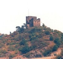
Spätburgunder red (pinot noir). Burg Rheinstein (right),
one of the Rhine's oldest castles, sits on a 270-ft cliff across
the river from A'hausen; originally called the Vogtsburg when
it was built ca 900 as a customs post, renamed Konigstein when
it served as home to the Holy Roman Emperor Rudolph von Habsburg
(1282-6) during his campaign against the robber-knights (see below),
controlled by the Archbishops of Mainz from the 14th-17th c, renamed
Rheinstein when its ruins were purchased and rebuilt (1825-9)
by von Lassaulx in pseudo-Gothic style for Prince Friedrich Wilhelm
Ludwig of Prussia, it was recently purchased (1975) and restored
by the Hecher family, who have opened it to the public
Assmannshausen (left; actually a part
of Rüdesheim), starting point for the cable car to the N-D,
is surrounded by hillsides of grapes - located on the western
side of the Rheingau, considered Germany's finest white wine district,
it's often called the "Red Island" for its locally famous
Spätburgunder red (pinot noir). Burg Rheinstein (right),
one of the Rhine's oldest castles, sits on a 270-ft cliff across
the river from A'hausen; originally called the Vogtsburg when
it was built ca 900 as a customs post, renamed Konigstein when
it served as home to the Holy Roman Emperor Rudolph von Habsburg
(1282-6) during his campaign against the robber-knights (see below),
controlled by the Archbishops of Mainz from the 14th-17th c, renamed
Rheinstein when its ruins were purchased and rebuilt (1825-9)
by von Lassaulx in pseudo-Gothic style for Prince Friedrich Wilhelm
Ludwig of Prussia, it was recently purchased (1975) and restored
by the Hecher family, who have opened it to the public
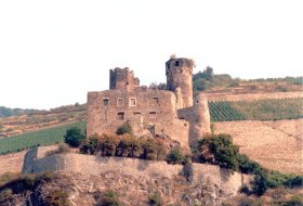
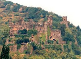
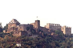
 Just downstream on a cliff above Trechtingshausen
(site of St Clement's Chapel) sits the massive 11th c Schloss
Reichenstein (left); the stronghold of a band of robber-knights
(initially led by Gerhard von Rheinbodo and his descendents, then
by Phillip von Hohenfels of the von Bolanden family) who preyed
upon river travelers in the 13th c, it was finally captured and
razed by the Emperor in 1290; rebuilt shortly thereafter and given
to the Archbishops of Mainz in 1344 (who leased it out for the
next 150 years), it was bought as a ruin in the 19th c by Baron
von Barfuss, renovated by the architect Strebel (1899-1902) for
the iron mogul Nicholas Kirsch-Puricelli - the castle is now open
to the public, and part of it serves as a hotel. On another left-bank
cliff nearby sits Burg Sooneck (right), another castle of the
robber-knights; dating from the early 11th c, it was destroyed
by the Emperor in 1282, rebuilt in the 14th c, eventually renovated
(ca 1843 by the military engineer Karl Schnitzler) as a hunting
lodge for King Friedrich Wilhelm IV of Prussia - it is now open
to the public
Just downstream on a cliff above Trechtingshausen
(site of St Clement's Chapel) sits the massive 11th c Schloss
Reichenstein (left); the stronghold of a band of robber-knights
(initially led by Gerhard von Rheinbodo and his descendents, then
by Phillip von Hohenfels of the von Bolanden family) who preyed
upon river travelers in the 13th c, it was finally captured and
razed by the Emperor in 1290; rebuilt shortly thereafter and given
to the Archbishops of Mainz in 1344 (who leased it out for the
next 150 years), it was bought as a ruin in the 19th c by Baron
von Barfuss, renovated by the architect Strebel (1899-1902) for
the iron mogul Nicholas Kirsch-Puricelli - the castle is now open
to the public, and part of it serves as a hotel. On another left-bank
cliff nearby sits Burg Sooneck (right), another castle of the
robber-knights; dating from the early 11th c, it was destroyed
by the Emperor in 1282, rebuilt in the 14th c, eventually renovated
(ca 1843 by the military engineer Karl Schnitzler) as a hunting
lodge for King Friedrich Wilhelm IV of Prussia - it is now open
to the public
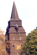
 Just downstream, Burg Heimburg, with
its 82-ft tower, sits at the mouth of the Heimbach Valley above
the left-bank towns of Ober- and Niederheimbach (left) - the steeple
of the 13th c St. Margareta parish church is visible on the right;
the castle's ruins were purchased in the 19th c and rebuilt as
a summer residence by Hugo Stinnes - still owned by the Stinnes
family, it's not open to the public. On the same bank further
downstream above the village of Rheindiebach, the ruins of the
13th c Burg Furstenberg (right) sport a matching 82-ft tower;
along with many of its neighbors, it was destroyed by the French
in 1689
Just downstream, Burg Heimburg, with
its 82-ft tower, sits at the mouth of the Heimbach Valley above
the left-bank towns of Ober- and Niederheimbach (left) - the steeple
of the 13th c St. Margareta parish church is visible on the right;
the castle's ruins were purchased in the 19th c and rebuilt as
a summer residence by Hugo Stinnes - still owned by the Stinnes
family, it's not open to the public. On the same bank further
downstream above the village of Rheindiebach, the ruins of the
13th c Burg Furstenberg (right) sport a matching 82-ft tower;
along with many of its neighbors, it was destroyed by the French
in 1689
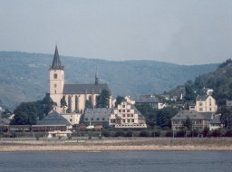
 The town of Lorch (left), at the northwestern
corner of the Rheingau, was officially recorded as a "wine
town" in 1085, but is several centuries older - it sits on
the river's right bank at the mouth of the Wisper River valley;
its Gothic parish church, St Martin's, contains the largest carved
alter (1483, by Hans of Worms) in the country. The ruins of the
11th c Burg Nollig, once part of the town's fortifications, are
perched on a hilltop at the confluence of the Wisper (right) -
the small tower nearest the hillside has recently been restored
by its private owners
The town of Lorch (left), at the northwestern
corner of the Rheingau, was officially recorded as a "wine
town" in 1085, but is several centuries older - it sits on
the river's right bank at the mouth of the Wisper River valley;
its Gothic parish church, St Martin's, contains the largest carved
alter (1483, by Hans of Worms) in the country. The ruins of the
11th c Burg Nollig, once part of the town's fortifications, are
perched on a hilltop at the confluence of the Wisper (right) -
the small tower nearest the hillside has recently been restored
by its private owners
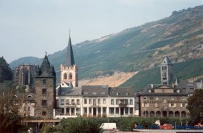
 Looking across the river, one first
sees Burg Stahleck high on a hill (left), then the town of Bacharach
(right) comes into view. Founded in the 10th c, before that a
Celtic settlement (according to legend named after the "Bacchi
ara," a huge rock in the Rhine used as an altar to the wine
god Bacchus, still the focus of a local celebration), the town
has been an important wine market since Medieval times; from far
left, the high Gothic ruins of the Werner-Kapelle (from ca 1400;
its roof was destroyed by debris when the town's castle was blown
up by Napoleon's retreating troops - who also razed the town),
the Martturm (one of 10 towers that used to be part of the town
wall), the spire of the Church of St Peter, and the Liebesturm
(tower of love)
Looking across the river, one first
sees Burg Stahleck high on a hill (left), then the town of Bacharach
(right) comes into view. Founded in the 10th c, before that a
Celtic settlement (according to legend named after the "Bacchi
ara," a huge rock in the Rhine used as an altar to the wine
god Bacchus, still the focus of a local celebration), the town
has been an important wine market since Medieval times; from far
left, the high Gothic ruins of the Werner-Kapelle (from ca 1400;
its roof was destroyed by debris when the town's castle was blown
up by Napoleon's retreating troops - who also razed the town),
the Martturm (one of 10 towers that used to be part of the town
wall), the spire of the Church of St Peter, and the Liebesturm
(tower of love)
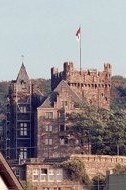
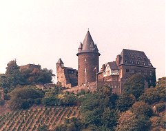
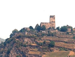
 The 11th c Burg Stahleck (left) was
originally owned by the Archbishops of Cologne, but in 1214 became
the seat of one of the counts Palatine (a rulers with special
powers granted by the Palace/Emperor), in 1356 (after the Golden
Bull of Charles IV) that of the Palatine Elector; it withstood
a siege by French troops during the 30 Years War, was renovated
by Elector Count Ludwig in 1666, destroyed when the French attacked
again in 1689, restored by the crown prince of Prussia in 1829,
renovated by the Rhine River Society starting in 1910 - and opened
to the public as a youth hostel in 1926. Just downstream, the
fortress of Pfalzgrafenstein (right; built by Ludwig of Bavaria
in 1326-7), stands sentinel on the rocky island of Falkenau near
the town of Kaub (the site of a daring river crossing by von Bluecher
and 60,000 Prussians on New Years Day of 1814 in their pursuit
of Napoleon) - once the most important toll station on the central
Rhine, its original pentagonal keep was surrounded by a 40-ft
high, turreted hexagonal wall (1338-42) in the form of a ship
and renamed the Pfalz after the castle was sold to the Palatine
counts; its outer walls were reinforced and a second level upper
walkway were added in 1607 by Prince Friedrich IV; never captured
during the many conflicts on this part of the Rhine, in 1803 the
castle was transfered to the Duchy of Nassau, in 1866 to the Kingdom
of Prussia, in 1946 to the German state of Rhineland-Palatine,
which renovated it in the early 1970s - it is open to the public
(when water levels permit)
The 11th c Burg Stahleck (left) was
originally owned by the Archbishops of Cologne, but in 1214 became
the seat of one of the counts Palatine (a rulers with special
powers granted by the Palace/Emperor), in 1356 (after the Golden
Bull of Charles IV) that of the Palatine Elector; it withstood
a siege by French troops during the 30 Years War, was renovated
by Elector Count Ludwig in 1666, destroyed when the French attacked
again in 1689, restored by the crown prince of Prussia in 1829,
renovated by the Rhine River Society starting in 1910 - and opened
to the public as a youth hostel in 1926. Just downstream, the
fortress of Pfalzgrafenstein (right; built by Ludwig of Bavaria
in 1326-7), stands sentinel on the rocky island of Falkenau near
the town of Kaub (the site of a daring river crossing by von Bluecher
and 60,000 Prussians on New Years Day of 1814 in their pursuit
of Napoleon) - once the most important toll station on the central
Rhine, its original pentagonal keep was surrounded by a 40-ft
high, turreted hexagonal wall (1338-42) in the form of a ship
and renamed the Pfalz after the castle was sold to the Palatine
counts; its outer walls were reinforced and a second level upper
walkway were added in 1607 by Prince Friedrich IV; never captured
during the many conflicts on this part of the Rhine, in 1803 the
castle was transfered to the Duchy of Nassau, in 1866 to the Kingdom
of Prussia, in 1946 to the German state of Rhineland-Palatine,
which renovated it in the early 1970s - it is open to the public
(when water levels permit)
 Behind Kaub, on a rocky ridge above
a steep terraced hillside of grapes, Burg Gutenfels (left) was
once one of the most important fortresses on the Rhine; built
ca 1200 by the count of Falkenstein, it survived a siege during
the War of German Succession (after the death of Conrad IV) in
1252, became part of the Palatine (together with Kaub) in 1277,
was home to Adolf of Nassau before his election in 1292 as Holy
Roman Emperor, was renamed Gutenfels in 1508 after withstanding
a 4-yr siege in the Bavarian-Palatine War of Succession, was besieged
again by the Spanish allies of the Landgrave of Hessen in 1620,
was finally captured by the Swedish allies of Hessen in 1632 -
whose troops were displaced by the French in 1645, was captured
again by the French in 1793; its ruins were rescued in 1833 by
the archivist Friedrich Habel, renovated by the architect Gustav
Walter in 1889-92, briefly served as a rest home, then as a youth
conference center, in the 1950s - its three-story palace and 95-ft
high tower are now a hotel. Downstream, on the opposite bank,
the Medieval town of Oberwesel (right; called Wasalia in the 5th
c by the Franks, renamed Wesel in 966 by Kaiser Otto I) still
has nearly all of its almost two miles of fortified walls intact,
as well as 16 of its original 21 towers, including the turreted
Ochsenturm, now a river semaphore station - the Gothic Martinskirche,
with its distinctive tower, dominates this view of the town
Behind Kaub, on a rocky ridge above
a steep terraced hillside of grapes, Burg Gutenfels (left) was
once one of the most important fortresses on the Rhine; built
ca 1200 by the count of Falkenstein, it survived a siege during
the War of German Succession (after the death of Conrad IV) in
1252, became part of the Palatine (together with Kaub) in 1277,
was home to Adolf of Nassau before his election in 1292 as Holy
Roman Emperor, was renamed Gutenfels in 1508 after withstanding
a 4-yr siege in the Bavarian-Palatine War of Succession, was besieged
again by the Spanish allies of the Landgrave of Hessen in 1620,
was finally captured by the Swedish allies of Hessen in 1632 -
whose troops were displaced by the French in 1645, was captured
again by the French in 1793; its ruins were rescued in 1833 by
the archivist Friedrich Habel, renovated by the architect Gustav
Walter in 1889-92, briefly served as a rest home, then as a youth
conference center, in the 1950s - its three-story palace and 95-ft
high tower are now a hotel. Downstream, on the opposite bank,
the Medieval town of Oberwesel (right; called Wasalia in the 5th
c by the Franks, renamed Wesel in 966 by Kaiser Otto I) still
has nearly all of its almost two miles of fortified walls intact,
as well as 16 of its original 21 towers, including the turreted
Ochsenturm, now a river semaphore station - the Gothic Martinskirche,
with its distinctive tower, dominates this view of the town
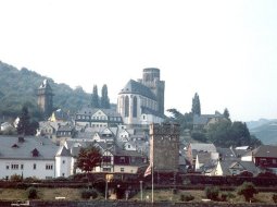 The pride of Oberwesel, however, is
the red sandstone, high Gothic Liebfrauenkirche ("church
of our lady"; left - begun in 1308) - located south of town,
the church has a 114-ft high nave (its decorations include the
oldest known rendering of the town of Koblenz), a tower containing
five bells cast between 1353 and 1404, a hand-carved, gilded main
altar (1331) with several early 16th c altarpieces, and an 18th
century baroque organ by the master Franz Joseph Eberhardt. Directly
above the church, Burg Schonburg (right)
The pride of Oberwesel, however, is
the red sandstone, high Gothic Liebfrauenkirche ("church
of our lady"; left - begun in 1308) - located south of town,
the church has a 114-ft high nave (its decorations include the
oldest known rendering of the town of Koblenz), a tower containing
five bells cast between 1353 and 1404, a hand-carved, gilded main
altar (1331) with several early 16th c altarpieces, and an 18th
century baroque organ by the master Franz Joseph Eberhardt. Directly
above the church, Burg Schonburg (right)
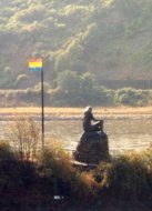
 Just downstream, the 430-ft high, stark
slate cliff of the Loreley (left) squeezes the river channel into
its narrowest (just over 300 ft), deepest, and most dangerous
point; a statue of the legendary river siren (right; 1983, by
Natascha Jusopov) now sits on a nearby island - her current personification,
supposedly first described by the German writer Clemens Brentano
in his novel "Godwi," was made famous in an 1823 poem
by Heinrich Hein (translated by Mark Twain in 1880) which has
been set to music by more than 25 composers
Just downstream, the 430-ft high, stark
slate cliff of the Loreley (left) squeezes the river channel into
its narrowest (just over 300 ft), deepest, and most dangerous
point; a statue of the legendary river siren (right; 1983, by
Natascha Jusopov) now sits on a nearby island - her current personification,
supposedly first described by the German writer Clemens Brentano
in his novel "Godwi," was made famous in an 1823 poem
by Heinrich Hein (translated by Mark Twain in 1880) which has
been set to music by more than 25 composers
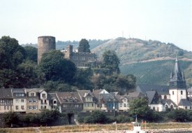
 The town of St. Goar (left) sits on
the opposite bank a few hundred yards downstream - its name derives
from the saint who brought Christianity to the people of the central
Rhine area in the 6th c; while the town's architectural focus
is the Church of St Goar, which originally combined elements of
both Romanesque and Gothic styles but is actually a late 19th
c reconstruction (although it does have a famous cycle of Gothic
frescoes and a 1480 painting of the saint), it is better known
as a tourist town, complete with the world's largest cuckoo clock
and beerstein, and one of only two outlets in Germany for Steiff
teddy bears. Burg Rheinfels (right) is the largest fortress ruin
in Europe; built above St Goar in 1245 by Graf (Count) Dieter
von Katzenelnbogen, it was enlarged as a fortress over the next
three centuries, converted into a Renaissance mansion in the 16th
c by the Landgraves of Hesse, into an even larger and more formidable
fortress at the start of the 17th c; it withstood enemy attacks
for the next two centuries, but was finally destroyed by Napoleon's
troops in 1794 - it is now owned by the city, and houses a museum,
restaurant, and hotel
The town of St. Goar (left) sits on
the opposite bank a few hundred yards downstream - its name derives
from the saint who brought Christianity to the people of the central
Rhine area in the 6th c; while the town's architectural focus
is the Church of St Goar, which originally combined elements of
both Romanesque and Gothic styles but is actually a late 19th
c reconstruction (although it does have a famous cycle of Gothic
frescoes and a 1480 painting of the saint), it is better known
as a tourist town, complete with the world's largest cuckoo clock
and beerstein, and one of only two outlets in Germany for Steiff
teddy bears. Burg Rheinfels (right) is the largest fortress ruin
in Europe; built above St Goar in 1245 by Graf (Count) Dieter
von Katzenelnbogen, it was enlarged as a fortress over the next
three centuries, converted into a Renaissance mansion in the 16th
c by the Landgraves of Hesse, into an even larger and more formidable
fortress at the start of the 17th c; it withstood enemy attacks
for the next two centuries, but was finally destroyed by Napoleon's
troops in 1794 - it is now owned by the city, and houses a museum,
restaurant, and hotel
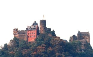
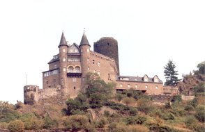
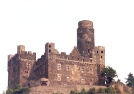
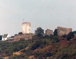
 Across the river, above the town of
St. Goarshausen, Burg Katz (left), and just beyond, Burg Maus
(left)
Across the river, above the town of
St. Goarshausen, Burg Katz (left), and just beyond, Burg Maus
(left)
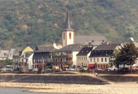
 On the left bank, in a horseshoe-shaped
curve of the river, Bad Salzig (left), site of a famous spa known
for its salt wells, is now a district of the town of Boppard (right),
which sits in a relatively open site on the left bank where several
small valleys meet; in Boppard, from left to right - the Kürfurstliche
Burg (electoral castle), built by Baldwin of Trier in 1327, the
twin spires of the Church of St Severus (1236), and at far right,
the spire of the Baroque-style Carmelite Church (1730; rebuilt
after the original 14th c church burned)
On the left bank, in a horseshoe-shaped
curve of the river, Bad Salzig (left), site of a famous spa known
for its salt wells, is now a district of the town of Boppard (right),
which sits in a relatively open site on the left bank where several
small valleys meet; in Boppard, from left to right - the Kürfurstliche
Burg (electoral castle), built by Baldwin of Trier in 1327, the
twin spires of the Church of St Severus (1236), and at far right,
the spire of the Baroque-style Carmelite Church (1730; rebuilt
after the original 14th c church burned)
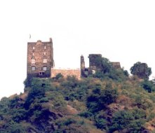
 Across the river, on a high bluff above
the town of Kamp-Bornhofen, the "Hostile Brothers" -
Burg Sterrenburg (left) and Burg Liebenstein (right) face each
other on adjoining promentories
Across the river, on a high bluff above
the town of Kamp-Bornhofen, the "Hostile Brothers" -
Burg Sterrenburg (left) and Burg Liebenstein (right) face each
other on adjoining promentories
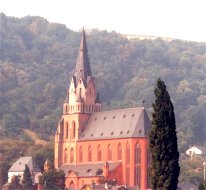
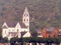
 In K-B, the major landmark is the Marien-Wallfahrts
cloister church (left). The town of Braubach, with its half-timbered
houses (center) and St Barbara Church (right; 1276), sits further
downstream as the river bends back to the north
In K-B, the major landmark is the Marien-Wallfahrts
cloister church (left). The town of Braubach, with its half-timbered
houses (center) and St Barbara Church (right; 1276), sits further
downstream as the river bends back to the north
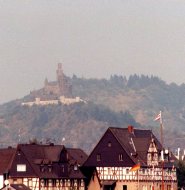
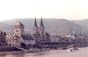
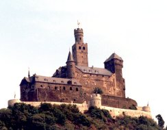
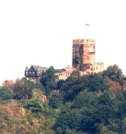
 Burg Marksburg (left), on a hill behind
Braubach; the left-bank town of Rhens (right)
Burg Marksburg (left), on a hill behind
Braubach; the left-bank town of Rhens (right)
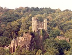
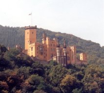
 Burg Lahneck (left), on a bluff above
the right-bank town of Lahnstein overlooking the mouth of the
river Lahn; on the left bank just south of Koblenz, the Schloss
Stolenfels (right)
Burg Lahneck (left), on a bluff above
the right-bank town of Lahnstein overlooking the mouth of the
river Lahn; on the left bank just south of Koblenz, the Schloss
Stolenfels (right)
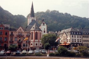
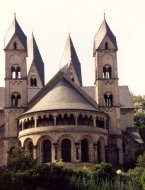
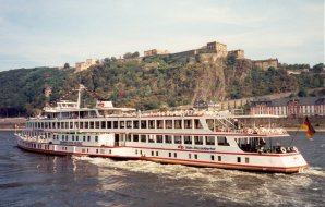
 Koblenz, at the confluence of the Moselle,
marks the end of the gorge; its Romanesque St. Castor's Church,
just behind the Koblenz wharf (left). The KD motor cruiser Wappen
von Mainz, with the Ehrenbreitstein Citadel (1816-32; built by
the Prussians after they took control of the city) on the cliff
across the river (right)
Koblenz, at the confluence of the Moselle,
marks the end of the gorge; its Romanesque St. Castor's Church,
just behind the Koblenz wharf (left). The KD motor cruiser Wappen
von Mainz, with the Ehrenbreitstein Citadel (1816-32; built by
the Prussians after they took control of the city) on the cliff
across the river (right)
Go to Germany-1 | Return
to Home Page