CENTRAL OREGON
(Last updated 12/9/07)
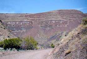
The formation of Oregon started about 200 million
years ago (mya) when the floor of the Pacific Ocean (expanding
along a SW to NE diagonal rift) collided with the North American
continent between the Klamath Mountains (then an island) and the
Hell's Canyon area on the Idaho border; the range of "coastal"
mountains initially formed can still be seen in the Blues and
Wallowas. This situation persisted until about 35 mya, when the
rift in the sea floor shifted to a line paralleling the present
coast and triggered episodes of explosive volcanic activity in
the western Cascades. These episodes lasted nearly 10 million years and covered
much of central Oregon with a layer of ash called the John Day
Formation, in some places to a depth of almost 1000 feet. Then
about 20 mya, volcanic activity shifted to the central and eastern
part of the state where, for the next 10 million years, molten
lava flowed from fissures in the earth's crust and incredible
quantities of basalt flooded nearly all of Oregon east of the
Cascades. The resulting blanket of lava, the second largest basalt
mantel in the world, covered over 10,000 square miles of the state
to a depth of several thousand feet, producing Oregon's high desert
plateau.
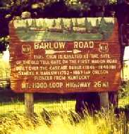
The historic one-room Smock Prairie
Schoolhouse (left) was recently moved to the town of Wamic, in
the foothills just west of Tygh Valley in Wasco county, and is
now a museum; an old, hand-carved sign (center) indicates that
Wamic is located near the first toll gate on the Barlow Road (1845-6;
the first overland route at the end of the Oregon Trail, the Road
wound over the Cascades through the TV from The Dalles to Oregon
City). White River Falls State Park, just to the east of TV, contains
the ruins of an historic hydroelectric plant (right), built in
1902 on a now dry tributary of the White to provide power for
the Wasco Milling Company in The Dalles (30 miles to the north);
the plant was expanded in 1910 after it was bought by PP&L

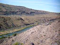
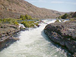
 Over the eons, the lower Deschutes
River [from "Riviere des Chutes," or River of the Falls,
coined by French fur traders during the early 1800s - a reference
to the proximity of the river's mouth to Celilo Falls (now covered
by the pool of the Dalles Dam; see Gorge)]
has cut a wide canyon more than 100 miles long and 2,000 ft deep
through the accumulated layers of rock. These
views are from a stretch of river about 10 miles south of Maupin
[located in the central canyon (on Hwy 197) at one of the few
access points to the lower stretch of the river]. One surprising
aspect of the canyon is the single track railroad line that runs
down its west side (left), the result of a railroad war (1909-11) between James J. Hill's Oregon
Trunk Railroad, a subsidiary of the Great Northern line, and Edward
H. Harriman's DesChutes Railroad, a Union Pacific subsidiary;
the war was waged with rifles and black powder between competing
crews that numbered in the thousands as they blasted into the
canyon walls and raced to lay track on opposite sides of the river.
The road on the east side of the canyon (right), which provides
access to the river for anglers and rafters along 35 miles of
the canyon in the Maupin area, occupies the railroad bed of the
war's losing side
Over the eons, the lower Deschutes
River [from "Riviere des Chutes," or River of the Falls,
coined by French fur traders during the early 1800s - a reference
to the proximity of the river's mouth to Celilo Falls (now covered
by the pool of the Dalles Dam; see Gorge)]
has cut a wide canyon more than 100 miles long and 2,000 ft deep
through the accumulated layers of rock. These
views are from a stretch of river about 10 miles south of Maupin
[located in the central canyon (on Hwy 197) at one of the few
access points to the lower stretch of the river]. One surprising
aspect of the canyon is the single track railroad line that runs
down its west side (left), the result of a railroad war (1909-11) between James J. Hill's Oregon
Trunk Railroad, a subsidiary of the Great Northern line, and Edward
H. Harriman's DesChutes Railroad, a Union Pacific subsidiary;
the war was waged with rifles and black powder between competing
crews that numbered in the thousands as they blasted into the
canyon walls and raced to lay track on opposite sides of the river.
The road on the east side of the canyon (right), which provides
access to the river for anglers and rafters along 35 miles of
the canyon in the Maupin area, occupies the railroad bed of the
war's losing side
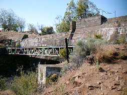
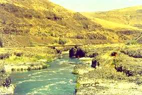
 Sherars Bridge (left) carries Hwy 216
across the Deschutes about 10 miles north of Maupin - it stands
about 50 miles from the mouth of the Deschutes at the site of
a toll bridge built by John Todd in 1860, where a basalt flow
tightly pinches the river; Joseph Sherar purchased the bridge
from Todd in 1871, then built approach roads down the canyon walls
and a 3-story tavern/inn nearby that was a major stop for travelers
until 1905. A view of Sherars Falls (right) shows the force of
the river as it carries on the slow proces of cutting its way
through another layer of hard basalt.
Sherars Bridge (left) carries Hwy 216
across the Deschutes about 10 miles north of Maupin - it stands
about 50 miles from the mouth of the Deschutes at the site of
a toll bridge built by John Todd in 1860, where a basalt flow
tightly pinches the river; Joseph Sherar purchased the bridge
from Todd in 1871, then built approach roads down the canyon walls
and a 3-story tavern/inn nearby that was a major stop for travelers
until 1905. A view of Sherars Falls (right) shows the force of
the river as it carries on the slow proces of cutting its way
through another layer of hard basalt.
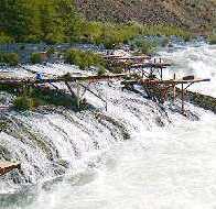
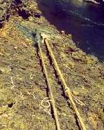
 Sherars Falls is lined with rickety
platforms projecting over the river (left), from which Native
Americans use long-handled dip nets (right) to catch fish; only
tribal members from the Warm Springs Indian Reservation have the
rather dangerous privilege of fishing this way
Sherars Falls is lined with rickety
platforms projecting over the river (left), from which Native
Americans use long-handled dip nets (right) to catch fish; only
tribal members from the Warm Springs Indian Reservation have the
rather dangerous privilege of fishing this way
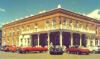
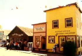
 Shaniko (supposedly the local Indian
pronunciation of pioneer rancher August Sherneckau's name) is
a not-quite ghost town (population around 40) located on US Hwy
97 about 20 miles southeast of Maupin and 70 miles north of Bend.
Shaniko was planned and built (1900) by businessmen in The Dalles
as the terminus for the Columbia Southern Railroad, and as a collection
station for the enormous quantities of wool being produced in
central Oregon - a role it played into the '40's. The Shaniko
Hotel (1900; left), a recently restored 2-story building with
18-inch thick walls made of handmade brick, has become a popular
destination, as it was for this convertible club during Shaniko's
Pioneer Days celebration; the Post Office (right) also opened
in 1900
Shaniko (supposedly the local Indian
pronunciation of pioneer rancher August Sherneckau's name) is
a not-quite ghost town (population around 40) located on US Hwy
97 about 20 miles southeast of Maupin and 70 miles north of Bend.
Shaniko was planned and built (1900) by businessmen in The Dalles
as the terminus for the Columbia Southern Railroad, and as a collection
station for the enormous quantities of wool being produced in
central Oregon - a role it played into the '40's. The Shaniko
Hotel (1900; left), a recently restored 2-story building with
18-inch thick walls made of handmade brick, has become a popular
destination, as it was for this convertible club during Shaniko's
Pioneer Days celebration; the Post Office (right) also opened
in 1900
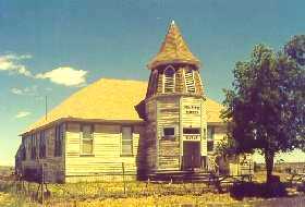
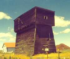
 The 3-room Shaniko School (left), which
housed kindergarten through high school, was built in 1901; the
wooden Water Tower (1900; right) contained two 10,000 gallon wooden
tanks to hold water pumped from nearby Cross Hollow canyon, which
was then sent to the town through a wooden pipe system
The 3-room Shaniko School (left), which
housed kindergarten through high school, was built in 1901; the
wooden Water Tower (1900; right) contained two 10,000 gallon wooden
tanks to hold water pumped from nearby Cross Hollow canyon, which
was then sent to the town through a wooden pipe system
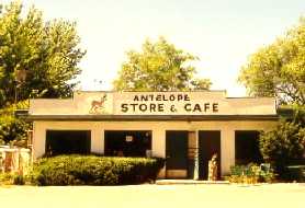
 The town
of Antelope (about 8 miles south of Shaniko on Hwy 218; left)
was the first settlement in the Antelope Valley region; the town
warranted a post office (Howard Maupin, postmaster) by 1871, and
was a center for cattle and sheep men in the 1890's; destroyed
by a fire in 1898, it was quickly rebuilt, but nevertheless became
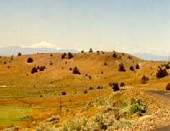
a ghost town after Shaniko was established. The hills to the southwest
of Antelope (near the Big Muddy Ranch, which was known as the
Rajneeshpuram in the 1980s) provide a view of Mt. Jefferson and
other Cascade peaks
The town
of Antelope (about 8 miles south of Shaniko on Hwy 218; left)
was the first settlement in the Antelope Valley region; the town
warranted a post office (Howard Maupin, postmaster) by 1871, and
was a center for cattle and sheep men in the 1890's; destroyed
by a fire in 1898, it was quickly rebuilt, but nevertheless became
a ghost town after Shaniko was established. The hills to the southwest
of Antelope (near the Big Muddy Ranch, which was known as the
Rajneeshpuram in the 1980s) provide a view of Mt. Jefferson and
other Cascade peaks
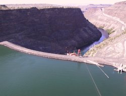
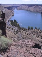
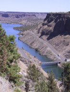
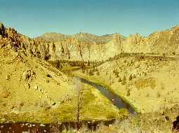
 A series of three dams block the Deschutes
River at the south end of the Warm Springs Indian Reservation.
Two large tributaries, the Metolius and Crooked Rivers, join the
Deschutes behind 400-ft high Round Butte Dam (left; constructed
in 1964) to form one of the more surprising and spectacular aspects
of the high desert, Lake Billy Chinook (right), named after a
Wasco Indian who guided the Freemont expedition of 1843 thru this
area.
A series of three dams block the Deschutes
River at the south end of the Warm Springs Indian Reservation.
Two large tributaries, the Metolius and Crooked Rivers, join the
Deschutes behind 400-ft high Round Butte Dam (left; constructed
in 1964) to form one of the more surprising and spectacular aspects
of the high desert, Lake Billy Chinook (right), named after a
Wasco Indian who guided the Freemont expedition of 1843 thru this
area.
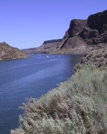
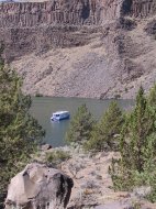
 The three arms of LBC, which fill the
deep canyons originally formed by these three rivers near their
confluence, provide 72 miles of shoreline and almost 4000 acres
of water with an average depth of over 100 ft. Watersking, fishing,
and houseboating provide year-round recreation
The three arms of LBC, which fill the
deep canyons originally formed by these three rivers near their
confluence, provide 72 miles of shoreline and almost 4000 acres
of water with an average depth of over 100 ft. Watersking, fishing,
and houseboating provide year-round recreation
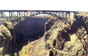
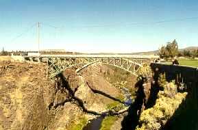
 Looking west from the Peter Skene Ogden
Scenic Wayside (in Jefferson County, about 3 miles north of Terrebonne),
a view (left) of the 350-ft steel arched span of the Oregon Trunk
Railroad bridge (1911; designed by Ralph Modjeski) over the Crooked
River Gorge - one of the highest in the country, it rises 320
ft above the water; built
to complete the railway from the Columbia River to Bend, ownership
of the site (which Oregon Trunk bought from the Central Oregon
Railroad in 1909) turned out to be the deciding factor in the
Deschutes railroad war. Just upstream
(to the east) on US Hwy 97 is the spandrel deck arch of the 464-ft
long Crooked River Gorge Bridge (1926; right), designed by Conde
B. McCullough; the Bridge will soon be part of the Wayside park
as a new 4-lane highway bridge has just been built to the east
- a construction stay tower is still visible in the upper left
of this pic.
Looking west from the Peter Skene Ogden
Scenic Wayside (in Jefferson County, about 3 miles north of Terrebonne),
a view (left) of the 350-ft steel arched span of the Oregon Trunk
Railroad bridge (1911; designed by Ralph Modjeski) over the Crooked
River Gorge - one of the highest in the country, it rises 320
ft above the water; built
to complete the railway from the Columbia River to Bend, ownership
of the site (which Oregon Trunk bought from the Central Oregon
Railroad in 1909) turned out to be the deciding factor in the
Deschutes railroad war. Just upstream
(to the east) on US Hwy 97 is the spandrel deck arch of the 464-ft
long Crooked River Gorge Bridge (1926; right), designed by Conde
B. McCullough; the Bridge will soon be part of the Wayside park
as a new 4-lane highway bridge has just been built to the east
- a construction stay tower is still visible in the upper left
of this pic.
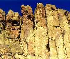
 Just east of Terrebonne (and about
23 miles north of Bend on US 97), Smith Rocks State Park is an
international destination for rock climbers and the number one
sport climbing area in the country. Smith Rock proper (a ledge
of welded John Day rhyolite ash) is the southernmost
of the formations in the area, an imposing massif roughly 1/2
mile long surrounded on three sides by a hairpin loop of the Crooked
River.
Just east of Terrebonne (and about
23 miles north of Bend on US 97), Smith Rocks State Park is an
international destination for rock climbers and the number one
sport climbing area in the country. Smith Rock proper (a ledge
of welded John Day rhyolite ash) is the southernmost
of the formations in the area, an imposing massif roughly 1/2
mile long surrounded on three sides by a hairpin loop of the Crooked
River.
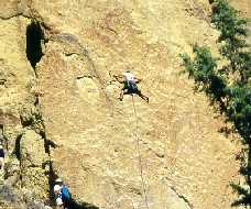
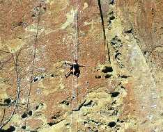
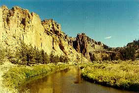 The highest peak in the area, The Summit,
is less that 1000 ft high, but sport climbing emphasizes technique
and physical conditioning rather than scaling great heights or
the use of artificial aids - although belay ropes are used for
safety. Thousands of routes (with ratings up to 5.14c), often
marked with the telltale of climbers' talc, have been mapped at
Smith, many of them short and near the ground, with fixed bolts
for anchor ropes permanently installed on more than a thousand
The highest peak in the area, The Summit,
is less that 1000 ft high, but sport climbing emphasizes technique
and physical conditioning rather than scaling great heights or
the use of artificial aids - although belay ropes are used for
safety. Thousands of routes (with ratings up to 5.14c), often
marked with the telltale of climbers' talc, have been mapped at
Smith, many of them short and near the ground, with fixed bolts
for anchor ropes permanently installed on more than a thousand
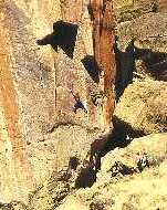
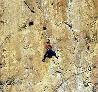 The names of various formations and
walls in the area - Asterisk Pass, Red Wall, Misery Ridge, The
Dihedrals - have become household words among the climbing fraternity
since a guide to the area was published by the Mazamas in 1962
The names of various formations and
walls in the area - Asterisk Pass, Red Wall, Misery Ridge, The
Dihedrals - have become household words among the climbing fraternity
since a guide to the area was published by the Mazamas in 1962
 Return to
Home Page
Return to
Home Page