The
GORGE-2
(Last updated 11/1/03)
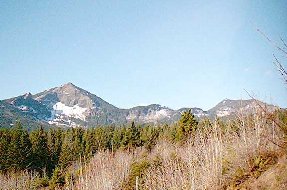
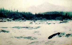
The Bonneville Landslide, in which the southern
halves of Greenleaf Peak and Table Mountain (left; located just
east of Hamilton) sloughed off, was the most recent of at least
four in the area. It blocked a 3 1/2 mile stretch of the Columbia
River, and many of the local Indian legends that mention the "Bridge
of the Gods" probably refered to the earthen dam initially
formed across the river by the slide. The dam, estimated to have
been over 200 feet high, created an inland lake over 100 miles
long before it was breached by the rising waters; in the process,
the course of the River was shifted almost a mile to the south.
Geologic and radiocarbon dating evidence indicates that the landslide
may have occurred less than 500, and perhaps as recently as 250,
years ago; in 1938 the stumps of nearly 2000 trees that had provided
visible confirmation of the recent nature of the slide were drowned
by the rising reservoir of Bonneville Dam. The reservoir also
buried the last uneroded remnants of the dam itself, huge chunks
of rock that formed a series of rapids (right; shown in a pic
of a Gorge interpretive sign) called (by John Fremont in 1843)
the "Cascades of the Columbia" - from which the mountain
range bisected by the rapids derived its name
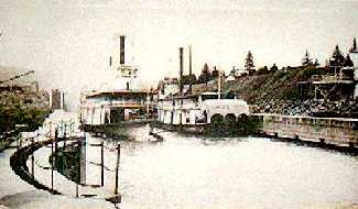
 The nearby settlement of Cascades first
prospered in the 1850's as steamboat traffic blossomed on the
River and a crude mule-powered "railroad" was built
there to provide portage services around the rapids; by 1862,
with boat traffic increasing rapidly on the River, a 5-mile long
portage railroad - powered by the Oregon Pony, the first steam
locomotive in the state - was built to move cargo and passengers
more efficiently. Finally, in 1876 Congress authorized the US
Army Corps of Engineers to design a canal around the rapids; the
version eventually finalized in 1881 was for a 7200-ft long by
90-ft wide canal containing a single 462-ft long lock, with a
lift of 36 feet. Construction began in 1886; the town changed
its name to Cascade Locks when the canal was finally completed
in 1896
The nearby settlement of Cascades first
prospered in the 1850's as steamboat traffic blossomed on the
River and a crude mule-powered "railroad" was built
there to provide portage services around the rapids; by 1862,
with boat traffic increasing rapidly on the River, a 5-mile long
portage railroad - powered by the Oregon Pony, the first steam
locomotive in the state - was built to move cargo and passengers
more efficiently. Finally, in 1876 Congress authorized the US
Army Corps of Engineers to design a canal around the rapids; the
version eventually finalized in 1881 was for a 7200-ft long by
90-ft wide canal containing a single 462-ft long lock, with a
lift of 36 feet. Construction began in 1886; the town changed
its name to Cascade Locks when the canal was finally completed
in 1896
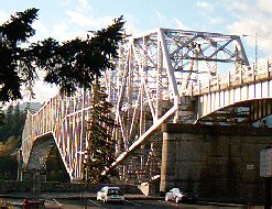
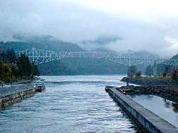
 The 1,858-ft long, cantilevered steel
trestle span of the man-made Bridge of the Gods (left), located
in Cascade Locks, was completed in 1926 on this narrowest part
of the river by the Wauna Toll Bridge Company; in 1938 the bridge
was raised to its present height of 135 ft above the water in
order to accomodate the rising reservoir of the Bonneville Dam.
The Bridge was acquired by the Port of Cascade Locks in 1961;
the Locks canal frames a twilight view of the Bridge (right)
The 1,858-ft long, cantilevered steel
trestle span of the man-made Bridge of the Gods (left), located
in Cascade Locks, was completed in 1926 on this narrowest part
of the river by the Wauna Toll Bridge Company; in 1938 the bridge
was raised to its present height of 135 ft above the water in
order to accomodate the rising reservoir of the Bonneville Dam.
The Bridge was acquired by the Port of Cascade Locks in 1961;
the Locks canal frames a twilight view of the Bridge (right)
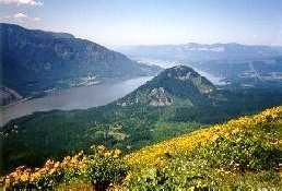
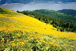
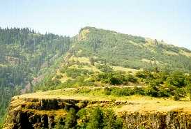
 View from the top of Dog Mountain (2,948
ft) - about 12 miles east of Cascade Locks on the Washington side
- looking west down the Columbia River, with Wind Mountain (1,000
ft) at center (left); looking out over a carpet of balsamroot
on Dog's southern slope, in late May (right)
View from the top of Dog Mountain (2,948
ft) - about 12 miles east of Cascade Locks on the Washington side
- looking west down the Columbia River, with Wind Mountain (1,000
ft) at center (left); looking out over a carpet of balsamroot
on Dog's southern slope, in late May (right)
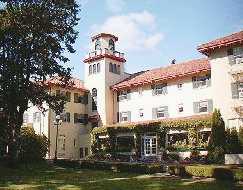
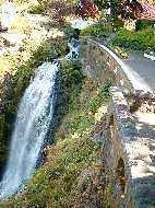
 The elegant Columbia Gorge Hotel (left),
located in what is now a western suburb of Hood River (wind surfing
capital of the world), was built in 1921 by timber baron Simon
Benson (early financial backer of the HCRH), restored in 1981
by the Graves family; its breakfast brunch is world famous. Another
unique feature of the hotel is Wah Gwin Gwin ("tumbling waters")
Falls on Phelps Creek, which plunges down to the Columbia over
a 208-ft basalt cliff (right) behind it
The elegant Columbia Gorge Hotel (left),
located in what is now a western suburb of Hood River (wind surfing
capital of the world), was built in 1921 by timber baron Simon
Benson (early financial backer of the HCRH), restored in 1981
by the Graves family; its breakfast brunch is world famous. Another
unique feature of the hotel is Wah Gwin Gwin ("tumbling waters")
Falls on Phelps Creek, which plunges down to the Columbia over
a 208-ft basalt cliff (right) behind it
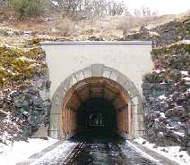
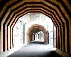
 The newly reopened 6.5 mile Hood River
to Mosier segment of the HCRH, designated for use by pedestrians
and bicyclists only, will be integrated into the HCRH State Trail.
The highlight of this segment is the stretch containing the 350-ft
long Mosier Twin Tunnels (by bridge designer Conde B. McCullough),
located about 5 miles east of Hood River - a view of the refurbished
eastern entrance (left); new cedar timbering lines the interior
of the tunnels, which had been filled with rubble in the '50s
(right)
The newly reopened 6.5 mile Hood River
to Mosier segment of the HCRH, designated for use by pedestrians
and bicyclists only, will be integrated into the HCRH State Trail.
The highlight of this segment is the stretch containing the 350-ft
long Mosier Twin Tunnels (by bridge designer Conde B. McCullough),
located about 5 miles east of Hood River - a view of the refurbished
eastern entrance (left); new cedar timbering lines the interior
of the tunnels, which had been filled with rubble in the '50s
(right)
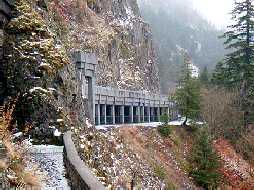
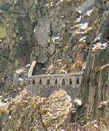
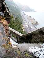
 The basalt cliffs above the Tunnels
were always unstable, but rock fall became so severe in 1953 that
the State Highway Engineer was forced to close this section of
the old highway and divert traffic to its new replacement (I-84)
even before the latter was officially completed. In order to safely
reopen the long-abandoned tunnels to pedestrians, HNTB Consultants
designed a 708-ft long rock catchment structure (left, center),
plus a section between the tunnels (right), with a 2-ft thick
sponge concrete roof capable of "catching" 5,000 pound
rocks dropping from a height of 200 feet (to prevent them from
bouncing off and falling onto the railroad tracks or I-84 below)
The basalt cliffs above the Tunnels
were always unstable, but rock fall became so severe in 1953 that
the State Highway Engineer was forced to close this section of
the old highway and divert traffic to its new replacement (I-84)
even before the latter was officially completed. In order to safely
reopen the long-abandoned tunnels to pedestrians, HNTB Consultants
designed a 708-ft long rock catchment structure (left, center),
plus a section between the tunnels (right), with a 2-ft thick
sponge concrete roof capable of "catching" 5,000 pound
rocks dropping from a height of 200 feet (to prevent them from
bouncing off and falling onto the railroad tracks or I-84 below)
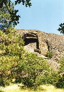
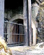 The "cliffwalk," an original
feature of the tunnels (now accessed from a gate between them),
runs along the face of the cliff (left) and provides a great view
of the highway and river below (center), as well as of the outside
of one of the two adits (right) - side tunnels that provide light
to the interior of the longer east tunnel
The "cliffwalk," an original
feature of the tunnels (now accessed from a gate between them),
runs along the face of the cliff (left) and provides a great view
of the highway and river below (center), as well as of the outside
of one of the two adits (right) - side tunnels that provide light
to the interior of the longer east tunnel
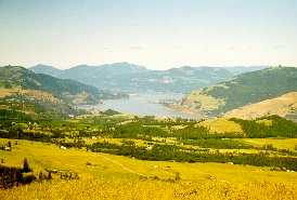
 Tom McCall Point (left) is a 1,722-ft
high promentory above the Rowena Plateau on the Oregon side of
the river just past Mosier (and about midway between Hood River
and The Dalles) - the area is owned by The Nature Conservancy,
and is a favorite among wildflower enthusiasts; view downriver
from the top of the Point (right)
Tom McCall Point (left) is a 1,722-ft
high promentory above the Rowena Plateau on the Oregon side of
the river just past Mosier (and about midway between Hood River
and The Dalles) - the area is owned by The Nature Conservancy,
and is a favorite among wildflower enthusiasts; view downriver
from the top of the Point (right)
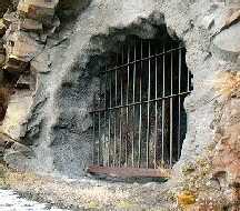
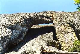
 The natural lava bridge in the Catherine
Creek canyon on the Washington side of the Gorge, almost directly
across the river from the Rowena Plateau
The natural lava bridge in the Catherine
Creek canyon on the Washington side of the Gorge, almost directly
across the river from the Rowena Plateau
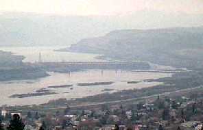
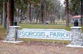
 For many years,
The Dalles (from "la Grande Dalle de la Columbia," the
voyageurs' rock-lined chute thru the rapids east of town) was
the overland end of the Oregon Trail; the prospect of continuing
on by a dangerous river journey down the Columbia (that claimed
the lives of nearly 1/3 of those who attempted it) prompted many
early immigrants to instead settle in the area. A view of the
1 1/2 mile long Dalles Dam (left) from the 15-acre Sorosis Park
(right) on the cliffs above the city - the Dam's completion in
1957 opened the upper river to modern navigation, but its reservoir
drowned Celilo Falls, a premier (and sacred) Indian fishing spot.
For many years,
The Dalles (from "la Grande Dalle de la Columbia," the
voyageurs' rock-lined chute thru the rapids east of town) was
the overland end of the Oregon Trail; the prospect of continuing
on by a dangerous river journey down the Columbia (that claimed
the lives of nearly 1/3 of those who attempted it) prompted many
early immigrants to instead settle in the area. A view of the
1 1/2 mile long Dalles Dam (left) from the 15-acre Sorosis Park
(right) on the cliffs above the city - the Dam's completion in
1957 opened the upper river to modern navigation, but its reservoir
drowned Celilo Falls, a premier (and sacred) Indian fishing spot.
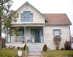
 The original Wasco County Courthouse
(left), built in 1859, is now a local historical museum; the Gothic
Revival-style N. H. Gates House (right), built around 1860, is
one of the city's oldest existing homes - Gates carried the city's
incorporation papers through the State legislature in 1852, and
was elected mayor five times
The original Wasco County Courthouse
(left), built in 1859, is now a local historical museum; the Gothic
Revival-style N. H. Gates House (right), built around 1860, is
one of the city's oldest existing homes - Gates carried the city's
incorporation papers through the State legislature in 1852, and
was elected mayor five times
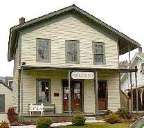
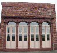
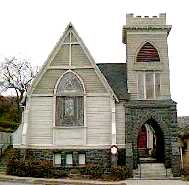
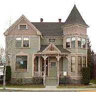
 The Baldwin Saloon (left), built in
1876 and now a restaurant, is one of the oldest commercial buildings
in the city - its facade is cast iron; the Carpenter Gothic-style
St. Paul's Church (center) was built in 1875 - the bell tower
was added in 1883; the Queen Anne-style Thompson House (right),
built in 1889, is representative of the many Victorians scattered
thruout the city
The Baldwin Saloon (left), built in
1876 and now a restaurant, is one of the oldest commercial buildings
in the city - its facade is cast iron; the Carpenter Gothic-style
St. Paul's Church (center) was built in 1875 - the bell tower
was added in 1883; the Queen Anne-style Thompson House (right),
built in 1889, is representative of the many Victorians scattered
thruout the city
 Go to Gorge-1 | Return to Home Page